Benefits to National Meteorological and Hydrological Services (NMHSs)
How do NMHSs benefit?
HydroSOS supports NMHSs delivering new or enhanced status and outlook information and products for their users including the agricultural, industry, energy and water supply sectors, as well as the general public.
Support, training and tools are being made available to help NMHSs increase their hydrological status and outlook capabilities for assessment and prediction of future conditions in their river basins.
By sharing their products through HydroSOS, NMHSs reach existing and new user communities at the national, regional and global scale, further demonstrating the benefits of their activities.
Through engaging with HydroSOS, NMHSs add value to their services by co-designing and refining products with their stakeholders and research and modelling communities.
Through product delivery, HydroSOS is key in leveraging political support for adequate funding for data collection, hydrological information, and capacity building operations in NMHSs.
Who will develop and run HydroSOS?
As the main providers of hydrological status and outlook information and products, NMHSs will operate HydroSOS with the support of the WMO.
Basin organisations and global and regional modelling centres will provide additional hydromet and climate information within the framework of HydroSOS.
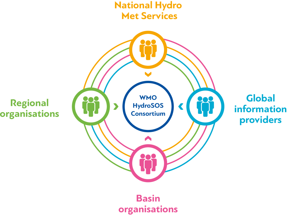
National hydro meteorological services, global information providers, basin organisations and regional organisations are all involved in the WMO HydroSOS Consortium.
HydroSOS methods and tools
HydroSOS focuses on improving the interoperability of systems, thus providing a framework for better integration and delivery of hydrological status and outlook products.
The initiative provides non-prescriptive guidance to NMHSs, depending on their evolving needs and capacities, to decide on which methods, models or tools could be set up to develop and provide products that meet their user needs.
HydroSOS technical approaches
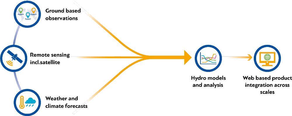
Ground based observations, remote sensing including satellite, water and climate forecasts lead to hydro models and analysis, which leads to web based product integration across scales.
How does HydroSOS fit with WMO initiatives?
Supporting the full value-chain: HydroSOS is the key to achieving the WMO hydrological ambition six 'We have a thorough knowledge of the water resources of our world'. It is an integral part of the value chain from data to information and knowledge and relates to the following initiatives.
Hydrological monitoring and data exchange:
- World Water Data Initiative (WWDI): HydroSOS will take advantage of this initiative which seeks to support countries into developing appropriate policies for water data sharing and exchange.
- WMO Global Hydrometry Support Facility (WMO HydroHub): HydroHub builds operational systems and capacity in hydrometry and water monitoring (Hydrological Cycle Observing System WHYCOS), expands the base of hydrological data and exchange capabilities and facilitates free and open data sharing (WMO Hydrological Observations System (WHOS)).
Hydrological modelling and forecasting and product dissemination:
- Flood Forecasting Initiative (FFI): WMO covers a range of activities that support flood forecasting and dissemination of warnings, such as the Flash Flood Guidance System (FFGS). It promotes integration of climate and weather information for flood forecasting, linking to activities for sever weather prediction (SWFDP) and coastal inundation forecasting (CIFI).
- Seamless Global Data-processing and Forecasting System (S/GDPFS): HydroSOS will provide products as a contribution to the S/GDPFS to make available water related information of relevance to the mandate of WMO across all timescales, as part of the Earth system approach.
- Regional Climate Outlook Forums (RCOFs): HydroSOS will encourage to link objective regional climate outlooks with hydrological outlooks and will become the means for the hydrological community to provide specifications and user needs to the development of climate outlooks.
Decision making:
- The Associate Programme on Flood Management (APFM) and Integrated Drought Management Programme (IDMP) offer institutional support and guidance for flood and drought management respectively.