Loading...
Loch Mhaolach-coire
Water body ID 10065
Loch Mhaolach-coire is a very small freshwater lake located in Highland, Scotland. It is generally shallow and is situated at mid altitude, with its catchment dominated by peat.
| Surface area | 7 ha |
| Mean depth [i] | 5.3 m |
| Catchment area | 195 ha |
| Grid reference | NC27661943 |
| Elevation | 267 m A.O.D. |
| Perimeter length | 1 km |
| Shoreline development index [?] | 1.25 |
| Fetch distance [?] | 0.49 km |
| Distance to sea [?] | 9.12 km |
| Water body volume [?] | 395657 m3 |
| Catchment-to-lake ratio [?] | 26.3 |
| Elevation type | Mid elevation |
| Size type | Very small |
| Depth type | Shallow |
| Geology type | Marl lake |
| Humic type | Unavailable (no data) |
| Mean conductivity | 139 µS/cm |
| Marl water body [?] | 10065 |
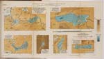
The following connectivity metrics are preliminary results from the NERC Hydroscape project and show a small sample of the data created for analysing the connectedness of lakes. As well as the hydrological catchment, various buffers were created outwards from the lake outline — the largest (2km) is shown below.
| Catchment mean elevation [?] | 337.49 m |
| Catchment mean slope [?] | 10.47 ° |
| Catchment strahler 1 length [?] | 1528.69 m |
| 2km buffer river length [?] | 21404.56 m |
| 2km buffer ponds perimeter [?] | 910.90 m |
Water quality monitoring data for this lake is available from the EA water quality service.
The below dropdown is prepopulated with a list of popular determinands.
The development of the database was jointly funded by the Environment Agency, Natural England, Countryside Council for Wales, and the Scotland and Northern Ireland Forum for Environmental Research (SNIFFER). Lake polygon geometry in Northern Ireland is based upon Crown Copyright and is reproduced with the permission of Land & Property Services under delegated authority from the Controller of Her Majesty's Stationery Office, Crown copyright and database rights, EMOU206.2. Northern Ireland Environment Agency Copyright 2015. Lake polygon geometry in Great Britain is based on Ordnance Survey data and contains public sector information licensed under the Open Government Licence v3.0. Data about species occurrence presented on this page is provided by the National Biodiversity Network (NBN) and its use is subject to the NBN Atlas Terms and Conditions.